The 1950 United States Census population schedules will be released this coming Friday, 1 April 2022, with a name index of unknown quality. A better index will follow shortly after the Ancestry.com handwriting transcription tool and FamilySearch volunteers have corroborated the index - perhaps within a month or two. Joel Weintraub and Steve Morse have developed Enumeration District tools over the past ten years for the 1950 Census for genealogists to use in the time before we have a reliable index.
Jen Rickards posted 1950 Census - Ancestry's Explore Maps Feature on her Auntie Jen's Family Trees on Friday, having discovered something new on her Ancestry home page. Please red her entire post. I have it on my Ancestry home page too, and my guess is that everybody else does too. If you don't, you probably will have it shortly.
The Ancestry "Explore Maps" feature looks like this on the home page:
Clicking on the "Explore Maps" link brings up a search page for a location:I typed in "san diego" and then selected it from the dropdown list. Clicking on "Search" I saw a map of San Diego from about 1950 2020 time:
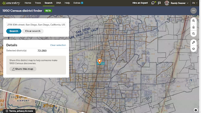
The map shows the outline of Enumeration Districts (ED) without numbers. Zooming in on the map, since I know where on the map my address (2119 30th Street) is located, I can run my mouse over the right location on the map and see:
And there it is - the Enumeration district is 72-293.
What if you don't know where the street address is on the map? Back on the second image above are circles with numbers in them. click on the one nearest your target area. The one over the Southwest USA has a number 447.
I clicked on that, and then again on the number over Southern California, and again on the number over San Diego and added my address, and picked the correct link from the dropdown menu: The system "flew" to the correct location on the map and displayed the same ED number, 72-293.
I tried this on several other addresses of interest and the system worked well, at least in cities of some size. It is possible that it won't work well for places that don't have street addresses or have farm locations.
This feature is a very helpful tool for Ancestry users to find the Enumeration districts for their 1950 U.S. Census searches.
I created a word processing table to list my addresses and ED numbers for the 1950 U.S. census in https://www.geneamusings.com/2022/03/rabbit-holes-with-randy-preparing-for.html.
Thank you to Jen Rickards for "finding this feature first" and exploring it.
UPDATE: As Marshall commented, the first map above on Ancestry is a semi-current map rather than from the 1950 time. It still works, though, but there were not nearly as many streets in San Diego and its suburbs in 1950.
Disclosure: I receive a complimentary all-access subscription from Ancestry.com, for which I am thankful. Ancestry.com has provided material considerations for travel expenses to meetings, and has hosted events and meals that I have attended in Salt Lake City, in past years.
The URL for this post is: https://www.geneamusings.com/2022/03/exploring-1950-us-census-ed-finder-tool.html
Copyright (c) 2022, Randall J. Seaver
Please comment on this post on the website by clicking the URL above and then the "Comments" link at the bottom of each post. Share it on Twitter, Facebook, or Pinterest using the icons below. Or contact me by email at randy.seaver@gmail.com.


4 comments:
This is a very handy new feature and it worked perfectly for a few EDs that I hadn't found using other methods. Ready for April 1st!
> I saw a map of San Diego from about 1950 time
Sorry, Randy, but a map that shows Interstate 5 (let alone I-15) is not from the 1950s.
Good catch, Marshall. I was in a hurry an looked only at my small part of San Diego which hasn't changed a lot since the 1950s. It appears to be a current San Diego map being used, and my guess is that Google or Bing (or similar) maps were used for this tool.
A closer looks at the maps for San Diego shows me two maps - one from about 1950 (it does show the Wabash Freeway (now I-15) but not the many streets added since then. The other, which I showed in the screen shot, is from the 2020 era map.
Post a Comment