I go down this type of rabbit hole every month or two, and I did this on Tuesday this week in several hours. An interesting journey down the hole and back to sunlight.
1) I am working on the David Bathrick (1722-1794 of Westborough, Massachusetts) biographical sketch for the 52 Ancestors post on Friday, and realized I had not looked for Deed records for him.
FamilySearch has the Massachusetts Land Records, 1620-1986 collection on digital microfilm (not with a searchable indexed):
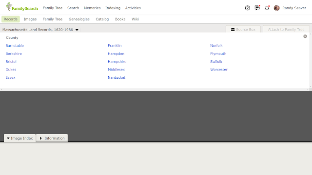
The user has to Browse these records - and there are over 5 million images. But it is waypointed (thank God!). I clicked on the "Browse all 5,766,135 images" button on the screen above, and saw the list of Counties:
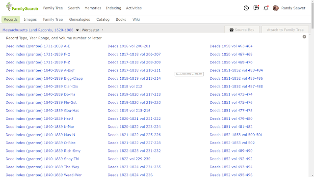
I clicked on the link for "Worcester" County on the list above:
There are hundreds of links on this page in three columns - first are the Deed index books (grantees and then grantors) for selected years, then the Deed books number 1 through 714; they go up to 1865 at this time.
2) To find deeds for a specific person, the user has to use the Grantee index (for those that bought or received land) and the Grantor index (for those that sold or gave land).
Since David Bathrick (1722-1794) lived in the 18th century, it made sense to search the "Deed index (grantee) 1731-1839 A-E" book - the first one on the list. And then the "Deed index (grantor) 1731-1839, A-C" book (further down the list above).
Here is part of the Index page for David Bathrick:
There are only two deeds listed in this grantee index (in the left-most column, near the bottom of the image), and I need to capture them.
I wrote them down, but decided to use a word processor table to avoid having to read my own handwriting. In the process, I captured all of the entries in the Grantee and Grantor indexes for David Bathrick. I put them in the word processor table.
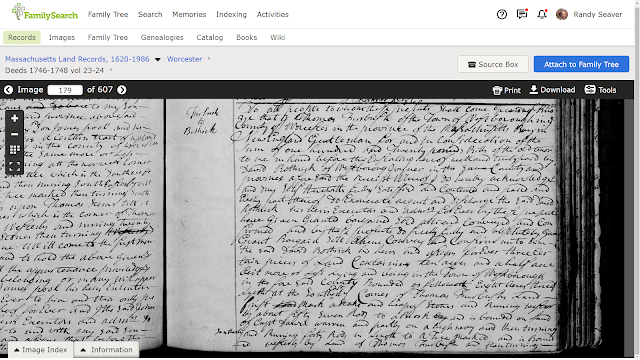
3) Then I went into each Deed volume to capture the deed images from the Deed books. Here is the first deed, from Volume 23, page 338, for Joseph Forbush selling ten and a half acres of land in Westborough to David Bathrick in 1747:
It is in the book "Deeds 1746-1748 vol 23-24" on image 179 of 607 (note that information at the top left of the image). I downloaded the image by clicking on the "Download" button in the upper right of the image. This deed continued for another page, so I downloaded that page too.
4) The downloaded file went into my "Downloads" computer file folder with a file name of "record-image_.jpg" so I needed to change the file name so I will know what it is. I saved it as: "DavidBathrick-1748-Deed-fromJosephForbush-WorcesterCoMA-Vol23-pg338-image179of607" using my file naming convention.
Then I downloaded the other deed images on my table list, and put them all in my David Bathrick family file folder. Here is an image of my downloaded deed files:
5) After adding and renaming the downloaded files, I updated my word processor table for the David Bathrick deed collection:
Note that I have added the image number to the "Image" column and also added "XX" to the DL column (downloaded). The next task is to write a source citation for each deed, add a Fact in the David Bathrick profile in my RootsMagic database, and abstract or transcribe the deed.6) Here is the source citation for the first deed on the list:
"Massachusetts, Land Records, 1620-1986," digital images, Church of Jesus Christ of Latter-Day Saints, FamilySearch (https://familysearch.org : accessed 8 February 2022), Worcester County, "Deeds, 1746-1748 Vol 23-24," Volume 23, pages 338-339 (images 179-180 of 607), Thomas Forbush to David Bathrick, executed 20 March 1747, recorded 10 May 1748; citing original records in County Courthouses, and on FHL Microfilms.
7) An abstract of the first deed is:
On 20 March 1747, Thomas Forbush, gentleman of Westborough, sold three tracts of land in Westborough for £120 in bills of credit to David Bathrick, joyner of Westborough. The tract of land was ten and a half acres in Westborough; eight acres bounded southerly by land of Thomas Forbush, Daniel Warren, on a highway, westerly by Thomas Forbush; two acres are on Chaney's plain, bounded southerly by a highway, northerly and westerly by Thomas Forbush; also one acre on the east end of Chaney's plain, bounded southerly by a highway, northerly on Cedar Swamp, and easterly by Daniel Warren. The deed was recorded on 10 May 1748.
8) I'm not done with this project - I need to source, enter into RootsMagic and abstract each deed on my table list. I've done the fun part - finding the records and downloading them. The rest is something I can do one at a time if I find a free ten minutes to work on them.
Where are my carrots to give me energy to complete all of these tasks? It's time for this genealogy bunny to have a snack!
NOTE 1: Almost every County in the United States has records like this. The indexing may be different. Another county may not have ALL of the records for the county (e.g., I'm quite sure that Deed indexes and deed books exist for Worcester County after 1865, the but Family History Library does not have them digitized).
NOTE 2: A great indexing project for FamilySearch would be to just index the Grantee and Grantor indexes - that would help all of us find these records more easily, although the user still would have to browse the images to find the record of interest.
Please comment on this post on the website by clicking the URL above and then the "Comments" link at the bottom of each post. Share it on Twitter, Facebook, or Pinterest using the icons below. Or contact me by email at randy.seaver@gmail.com.


No comments:
Post a Comment